C-MAP MAX NA-M026 – Great Lakes & The Maritimes – C-Card
Original price was: $279.00.$252.57Current price is: $252.57.
Manufacturer: C-MAP | Manufacturer Part Number: NA-M026C-CARD | UPC Code:
3 in stock

SKU: 30127
Manufacturer: C-MAP
Manufacturer Part Number: NA-M026C-CARD
UPC Code:
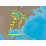
NA-M026 => Great Lakes, Northeast Coast and Approaches
Coverage of the Great Lakes, St. Lawrence River and Northeast United States. Coverage of the Great Lakes also includes Fox River and Lake Winnebago, Lake St. Clair, Rideau Canal, Ottawa River and the Trent-Severn Waterway. Includes all coastal charts for New Brunswick and Nova Scotia in Canada and Maine, New Hampshire, Massachusetts, Connecticut and New York in the U.S. Also included is coverage of the Hudson River and Lake Champlain as well as the Erie Barge Canal.
| Weight | 0.1 lbs |
|---|
General Enquiries
There are no enquiries yet.